Friday 27 May 2011

costal walks and the last of the mainland Marilyns


 Not much time for blogging at the momment, training has mainly been costal walks around the mainland, also Last 2 shetland marylins on the mainland done today approx 13kms in 3hrs. Dalescord hill 827ft and mid ward 564ft sunshine and light winds.

I have passed the 750 mile mark now with still 5 months left before leaving for base camp, hope to have reched 1500 miles before i go either by walking, cycling or rowing to make sure i give myself a fighting chance of making it

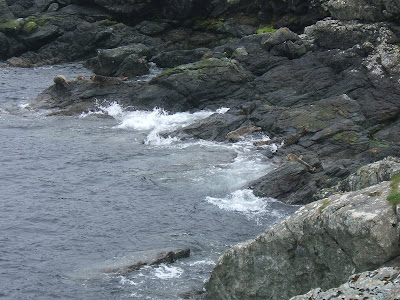
Earlier in the week  did a circuit of Fethaland details below, i was followed around the coast by about a dozen seals


Details

Distance: 10.5km
Difficulty: Moderate To Challenging
Duration: 5hours
Height Gain: 100m
Area Of Shetland: North Mainland
Starting Point: HU 371 909
End Point: HU 371 909
Map: OS Explorer 469: Shetland � Mainland North West

Description

FethalandIsbister is the starting point for this walk. Most of the going is straightforward, but care must be taken at the northern section, where cliff edges can be very dangerous, especially in wet or windy weather. Vehicles should be left where they will not block access to entrances, or inconvenience local farmers and residents.
Take the track that leads to east from Isbister, stopping at the old Kirkyard to examine some rare wooden grave-markers which can still be seen, standing here among the stone ones. Continue past the Loch of Housaquoy. where interesting duck and sometimes divers can be seen here at certain times of year.
Away to the right, an ancient monastic site existed on the Kame of Isbister, an inaccessible spur of rock, jutting out seawards from the cliffs here. It featured in the TV series "Extreme Archaeology" some years ago, as did a similar site directly opposite, on the west coast of Yell. Between May and August, the wild flowers along this walk can be wonderfully varied and colourful.
The track continues up north across hill and moor, fine views of Ronas Hill to the south until you reach the remains of the old fishing lodges at Fethaland itself. This was the largest of Shetland's fishing stations. with up to sixty boats operating between here and the "Far Haaf", which was the local name for the edge of the continental shelf, about 50 miles to the west. The boats were sixerens, open, six-oared wooden vessels, built along traditional Norse lines.
Immediately to the west of the lodges an Iron Age broch once stood, its mound providing the shelter here. There are other archaeological sites nearby, including the circular wall outlines of a large Neolithic house. In the sea washed shingle strata, you can still find occasional fish bones, relics of the industry which, long ago must have transformed the area into a noisy, smelly hive of activity at the time.
FethalandYou can continue into the final section of the headland to the lighthouse and look out for seals, gannets, and other seabirds. Cleber Geos contains an old soapstone, or steatite, quarry and is now a protected archaeological site. Notice the old names, carved in the worked rock face and the shapes of large stone bowls, which were carved from the soft soapstone. Troughs and bowls made from this rock have been found on many archaeological sites in Shetland.
Puffins sometimes nest at the northern end of the Isle of Fethaland in summer, and many shags and other seabirds nest among the cliffs and rocks. You can enjoy splendid views of Yell and the rarely accessible Gruney and the Ramna Stacks to the north.
Returning to the fishing station, you can now make your way up over the Hill of Breibister and on to the Pund of Setter the Lower Loch of Setter. Charles Ratter, the last Haaf skipper from Fethaland once crofted this very fertile area. From here the route is down to the loch and along the shore to Benigarth, with a splendid view of Sandvoe and back to Isbister.

Monday 9 May 2011

Ben Nevis

First major training challenge up and down Ben Nevis,
the rocks and scree paths are very similar to those on the trek in Nepal to EBC


Perfect weather as you can see from the pictures

up and down in 4hrs 20 mins including time for a snack and to take some pictures of the amazing view.

needed my poles for the summit as the snow had turned to ice and was very slippy.


Ben Nevis (Scottish Gaelic: Beinn Nibheis, pronounced [peˈɲivəʃ]) is the highest mountain in the United Kingdom and the whole of the British Isles. It is located at the western end of the Grampian Mountains in the Lochaber area of the Scottish Highlands, close to the town of Fort William.
As is common for many Scottish mountains, it is known both to locals and visitors as simply the Ben.[1][2] It attracts an estimated 100,000 ascents a year,[3] around three-quarters of which[4] are made using the well-constructed Pony Track from Glen Nevis on the south side of the mountain. For climbers and mountaineers the main attraction lies in the 700-metre (2,300 ft) high cliffs of the north face; among the highest cliffs in the United Kingdom, they harbour some classic scrambles and rock climbs of all difficulties, and are one of the principal locations in the UK for ice climbing.
The summit, at 1,344 metres (4,409 ft) above sea level, features the ruins of an observatory, which was permanently staffed between 1883 and 1904. The meteorological data collected during this period are still important for understanding Scottish mountain weather. C. T. R. Wilson was inspired to invent the cloud chamber after a period spent working at the observatory.


picture of my help for heroes vest drying in the sun, it was about 2 degrees at the summit, but was up to 17 degrees at the base and on the lower slopes, so i sweated alot and it needed airing!


Ben Nevis's altitude, maritime location and topography frequently lead to poor weather conditions, which can pose a danger to ill-equipped walkers. According to the observations carried out at the summit observatory from 1883–1904, fog was present on the summit for almost 80% of the time between November and January, and 55% of the time in May and June.[13] The average winter temperature was around −5 °C (23.0 °F),[13] and the mean monthly temperature for the year was −0.5 °C (31 °F).[14] In an average year the summit sees 261 gales,[14] and receives 4,350 millimetres (171 in) of rainfall, compared to only 2,050 millimetres (81 in) in nearby Fort William,[15] 840 millimetres (33 in) in Inverness and 580 millimetres (23 in) London. Rainfall on Ben Nevis is about twice as high in the winter as it is in the spring and summer. Snow can be found on the mountain almost all year round, particularly in the gullies of the north face – with the higher reaches of Observatory Gully holding snow until September most years and sometimes until the new snows of the following season.


On the way back to inverness i stopped off to pay my respects at the commando memorial,
you can see Ben Nevis in the background


The monument stands as a memorial to the British Commandos who trained all around the Lochaber region which the monument overlooks, while they were based at the Achnacarry Commando Training Centre established in 1942.[9][10][13] As such it is used as site for memorial services, including the 60th anniversary of D-Day, and Remembrance Day ceremonies.[8][14]
A Garden of Remembrance, which was subsequently added to the site, is used by many surviving Word War II Commandos as the designated final resting place for their ashes.[9][11] It has also been used as a place where many families have scattered ashes and erected tributes to loved ones who belonged to contemporary Commando units and who have died in more recent conflicts such as the Falklands War or in Afghanistan and Iraq.


fundraising going well but still need your help
 please visit the website to donate


Saturday 23 April 2011

POLE TO POLE

Tried out my walking poles for the first time today, with a climb up to another Shetland Marilyn, Scalla field  in Aith
as a man of a certain age with worn out knees, they really made a difference, especially on the way down


the climb follows the route of the Burn of lunklet to the waterfall below. then past the loch of lunklet upto a height of just under 1000ft (922) at the summit


It was a nice bright climb up, but the mist came down on the descent, lots of mountain hares, who have now got their  summer coats , with just a few patches of white left,


this area is well know for its red grouse which were introduced to Shetland to shoot in the early 1900s.but didn't see any today, may be the locals are all very good shots


Off to Ben Nevis on Tuesday weather permitting, praying for a day without fog both here in Shetland so the flight can take off and in Fort William so i can get a view from the summit


Happy Easter

Saturday 9 April 2011

BROKE BIKE MOUNTAIN

Started training for my GYM FOR HEROES, so put the bike in for a service, picked it up and a few days later, off i set, to work on toughing up another group of muscles, which i am far to polite to discuss on a blog.
4 miles into the hills and what happens?

so got an extra work out by having to carry the bike 3 miles back home to finish the circuit. great!

On the walking front, i completed my first long walk on mothers day,18.5 miles prior to taking everyone out for Tea at the lerwick hotel, top food but slightly sore feet


Today started on the rower and yes of course the run of good luck continues, as i type this with my good hand!
well that's it for this week,off to nurse my wounds and try and find a bagful of enthusiasm for next weeks training

Monday 28 March 2011

SHETLAND MARILYNS NOT THE MUNROS!

Started to concentrate more on height rather than distance. to build up the muscle and joint power required in Nepal

having already completed  two of the highest Marilyns in Shetland, Ronas Hill 450m and Fitful Head 283
 i have now added Sandness Hill 249 and Scrae Field 216 to that list, brilliant views from Scrae Field sadly the mist was down on Sandness, visibility was less than 25m so had to use my compass for the first time to find a safe route back down. an experience in itself after 20 years.

Also completed some sub Marilyns on route,


A Marilyn is "a hill of any height with a drop of 150 metres (nearly 500 ft) or more on all sides". In other words, a Marilyn is a hill which is relatively high compared to its surroundings. There are 19 Marilyns in Shetland.

Marilyns In Shetland

Click here for a map showing the 19 Marilyins in Shetland. (Marilyns appear as Type=M on this map).
The full list is as follows:


Name Height (Meters)Height (Feet) Map Reference 
Dalescord Hill 252 827 HU 39300 68400
Fitful Head  283928 HU 34633 13547
Hill of Arisdale 201689 HU 49500 84200
Mid Ward 172564 HU 32000 65200
Noss Head 181594 HU 55384 39886
Ronas Hill 4501476 HU 30529 83486
Royl Field 293961 HU 39594 28518
Sandness Hill 249817 HU 19171 55722
Saxa Vord 285935 HP 63121 16623
Scalla Field 281922 HU 38932 57260
Scrae Field 216709 HU 41790 36148
The Noup 248814 HT 95400 37500
The Sneug 4181371 HT 94780 39508
Valla Field 216709 HP 58462 07867
Vord Hill 159522 HU 62229 93521
Ward Hill 217712 HZ 20838 73402
Ward of Bressay 226741 HU 50287 38722
Ward of Scousburgh 263863 HU 38791 18803
White Grunafirth 173576 HU 27568 80731


Notes:

A 'sub-Marilyn' is a hill which just fails (by up to 10m) to qualify on the drop rule, i.e. drop of 140m to 149m on all sides.
The Marilyns are so-called by the list's compiler, Alan Dawson, after the more famous mountain list - the Munros.
You can learn more at the Marilyn News Centre website and also at this site about The Relative Hills Of Britain.

Thursday 10 March 2011

BLISTERS, BAD KNEES AND BEN NEVIS

While i might be sufferring from blisters and bad knees, i am still focused on the reason for me doing this trek, my few aches and pains are nothing compared to the trauma some of our forces suffer on a day to day basis, so to make sure i stay on track, i have decided to trek up Ben Nevis on the 26th of April, the trip expenses will be covered by my employer as i have to go to Inverness for business and will combine the two


Ben Nevis (Scottish Gaelic: Beinn Nibheis, pronounced [peˈɲivəʃ]) is the highest mountain in the United Kingdom and the whole of the British Isles. It is located at the western end of the Grampian Mountains in the Lochaber area of the Scottish Highlands, close to the town of Fort William.
As is common for many Scottish mountains, it is known both to locals and visitors as simply the Ben.[1][2] It attracts an estimated 100,000 ascents a year,[3] around three-quarters of which[4] are made using the well-constructed Pony Track from Glen Nevis on the south side of the mountain. For climbers and mountaineers the main attraction lies in the 700-metre (2,300 ft) high cliffs of the north face; among the highest cliffs in the United Kingdom, they harbour some classic scrambles and rock climbs of all difficulties, and are one of the principal locations in the UK for ice climbing.
The summit, at 1,344 metres (4,409 ft) above sea level, features the ruins of an observatory, which was permanently staffed between 1883 and 1904. The meteorological data collected during this period are still important for understanding Scottish mountain weather. C. T. R. Wilson was inspired to invent the cloud chamber after a period spent working at the observatory.